Cities / Inclusive design
An inclusive approach to rethink linear urban voids
By Silvia Bassanese and Cecilia Zecca | 15 Dec 2022 | 0
Silvia Bassanese and Dr Cecilia Zecca present a case study of linear urban voids formerly used for transportation in Aberdeen, Scotland, and now converted into a pedestrian and bicycle path.
Authors of scientific paper:

Abstract
Contemporary cities emerged as a result of diverse social, economic, urban and architectural transformations, through redevelopment and through cycles of abandonment and regeneration. In this complex scenario, the ubiquitous presence of urban voids raises interesting questions on how to exploit potential spaces in search of alternative and more inclusive models of circular economy and opportunity for all.
The story of urban voids is usually one of dysfunctional spaces, typically of unrealised intentions owing to their uncodified nature, which makes them fall within the category of secondary interventions. This paper questions the fallacy that the “space of the difference” in our cities can simply be adapted to conform to the predominant climate. Against the common strategy to treat these spaces as ancillary commodity, it’s becoming relevant to reassess their social value from the bottom up, in order to discover physical roots, theoretical foundations, and equitable access opportunities. The closer we get to the genesis of the urban voids, the more the story unravels, in the belief that margins of freedom for any form of sustainable intervention in the city can be rediscovered only through the retrieval of every aspect involved in the context.
A case study of linear urban voids formerly used for transportation in Aberdeen, Scotland, and now converted into a pedestrian and bicycle path is presented. A combination of methods has been used to understand the nature of these entities: rhythmic analysis, which involves interaction between senses, a multisensorial experience of the space in movement; and graphic interviews, which involve interpretative diagrams (mental map) that help visualise with patterns how people use and imagine the space.
By using these inclusive urban design methods, directly elaborated by people passing through the space, a taxonomy of design principles is outlined. What will happen if we consider the urban voids as never neutral and empty but rather as always “tensioned”, both made and occupied by forces that produce and use them? In this sense, the relational definition of architecture will prevail and the “pre-urban void” would be integrated in a network of relationships, where the architectural is only one of many possible codified forms of expression.
A deeper interaction between past, present and future emerges. If we’re able to include the notion of heterogeneity under broader perspectives, we could assert that urban voids embody active and equitable forms of social relations in our cities.
Keywords
Introduction
Decentralisation, de-industrialisation and the rise of the service economy have created multiform urban and architectural transformations in the contemporary city, along with divergent spatiality. New conditions, such as disused, empty or abandoned urban spaces, are gradually embodying realities where the city’s creative nature can strategically emerge. The city of Aberdeen in Scotland offers an ideal opportunity for researchers to identify the dynamics embedded in this process, because the alternating phases of economic growth and decline of the city have been quite rapid with dramatic consequences for the urban fabric. Various distinct categories of resulting spaces are generated during boom-and-bust cycles, where the voids left behind play a prominent role. Urban voids often have no specific margins and, alarmingly, they’re increasing found within the built city and, controversially, at the disadvantage of local identities.
In understanding the evolution of the urban complexity in relation to the architectural project, it’s worth examining the direct consequences in the form of the built city. This is the context where architects can apply their knowledge, intervene and confront problems in the attempt to reframe the public debate, and ensure that multiple perspectives are embraced. As Pier Vittorio Aureli discussed in The City as a Project1, the form of the city arises from constant interaction between ideas and spatial conditions, where the latter are triggered by the relationship between the built and the un-built. While it’s undeniable that developers continue to pursue programmes to erect buildings on every available area of the city and promote this process for its productivity, by doing so, various voids are simultaneously created. The urban fabric embodies the socio-economic dichotomy between the built and the un-built, with the tendency to simply “upgrading” the latter to the former. However, this paper suggests that many innovative ideas are possible, especially in light of favouring business with robust ESG (environmental, social and governance) frameworks.
In this paper, a specific geometrical configuration of void is selected and analysed: the linearity of the urban voids left by infrastructures for transportation. The results of research on areas either disused or formerly used for the rail transport in the city of Aberdeen are presented by using a revised version of the double diamond design process model. The four steps (discover, define, develop and deliver) draft similarities, threats and challenges from the problem to the solution. Using rhythmic urban analysis methods, observations, and investigations of the relational dynamics between the selected areas and their surrounding context, spatial and cultural codifications are discussed. Later, springing from the research, through design during the studio work at the Scott Sutherland School of Architecture and Built Environment in Aberdeen, a range of project ideas is presented as tangible results and proposals to overcome the intrinsic spatial condition of isolation in the urban context of the linear urban voids.
Context of research: Aberdeen and urban voids for transportation
Aberdeen represents an emblematic example of a city suffering the consequences of the global crisis, with parts of territory covered by empty units, vacant plots and abandoned areas. Well known for its maritime centre and industry, Aberdeen’s economy has been mainly focused on fishing, textile, shipbuilding and paper production, before the boom of oil and gas in the 1970s. Suddenly – and, perhaps, too rapidly – the entire economy has shifted towards the latter sector, resulting in controversial, even a lack, of policies in the management of the urban fabric. The so-called Granite City had already been badly hit by the collapse of oil prices before the pandemic, and the current situation with a pervasive presence of voids is simply exacerbating an already ongoing urban process. It’s worth mentioning that Aberdeen is sharing this quite problematic development with a large number of other cities in and beyond Europe, making it a privileged case study for the research. Obstructions including oblivion, local authorities, private landlords, and a promise of an impending upturn in the property market deny the hidden urbanity of the urban voids, treating them as spaces to commodify2. What is discussed in this paper is the presence of linear voids for transportations as dynamic elements in the urban fabric for more inclusive design approaches. Their existence represents an opportunity for divergent thinking.
During the last two centuries, the development of infrastructures between England and Scotland has evolved, establishing and modifying the urban configurations of the territories crossed by the new “speed lines”. It’s the case of the railway infrastructure connecting Aberdeen in the north with London in the south of the United Kingdom (see figure 1).
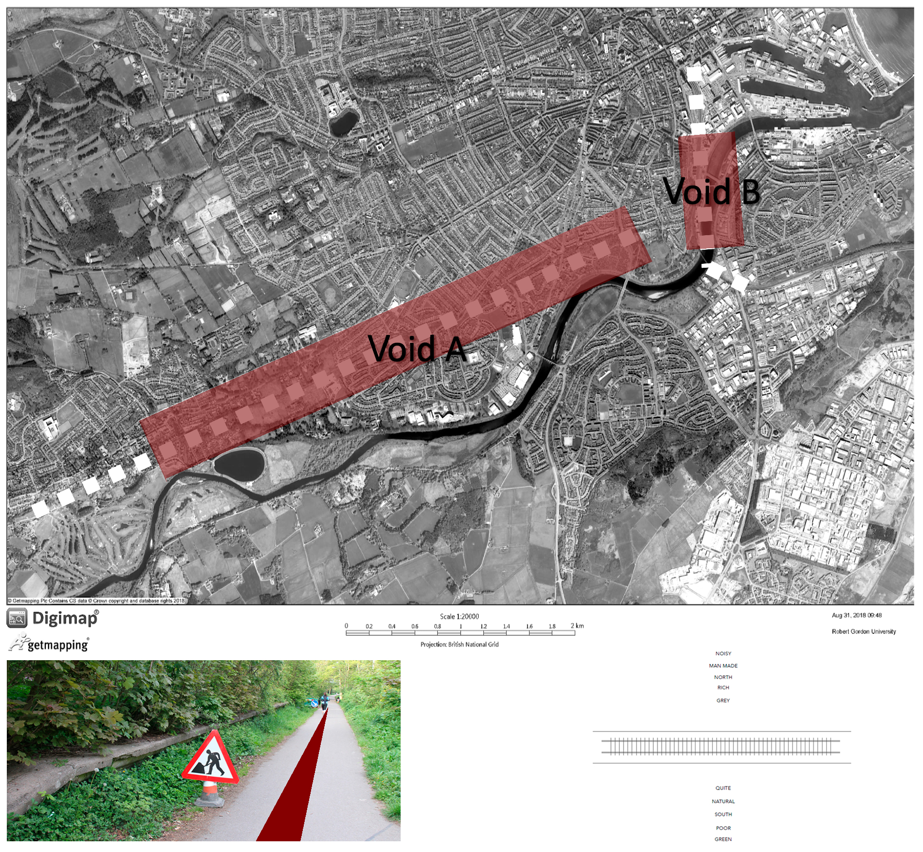
Between Aberdeen and Ballater, the royal family patronised the 43 miles railway, which became, in the late 19th century, a rich suburban commuter service. Known as the Deeside Railway, it was listed for closure in the 1963 Beeching report and finally closed in 1966, as a consequence of the decommission of uneconomic and underused railways3. Later replaced by the popular Deeside Way, the relations between the adjacent contexts, with their respective districts at the boundaries of this demarcation, have been modified4. Today, the track bed is converted into footpath and cycleway, but despite the apparent more sustainable outlook, it displays similar features across different locations and contexts, reiterating the twofold aspect of connection as infrastructure and of isolation as separating axis.
Methodology: An interpretation of the double diamond in the urban and architectural design fields
While this research is drawn on extensive and critically reviewed literatures on urban voids and their particular linear morphology5, the following methods describe the use of an innovative double diamond to analyse, define the problems, and develop coherent design principles for linear urban voids for transportation. The methodology is then corroborated through the description of the case study of Aberdeen.
The double diamond (DD) diagram6 is an established and well-known method used as a framework for innovation by designers. It enables one to follow a structured process based mainly on wide divergent thinking and more narrow convergent thinking. While there is no room here to provide an in-depth description of the development of the DD and its further intellectual formulations, it’s nonetheless possible to remind ourselves briefly of the four main actions of the DD: the first action discover involves an understanding of the users’ needs and aspirations; the second action define implies clear individuation of the problem; the third action develop includes a range of design solutions; the fourth and last action deliver implies the selection of the best practice and its prototype.
The diagram is here further developed through a set of subcategories of actions for each diagonal principle (see figure 2).
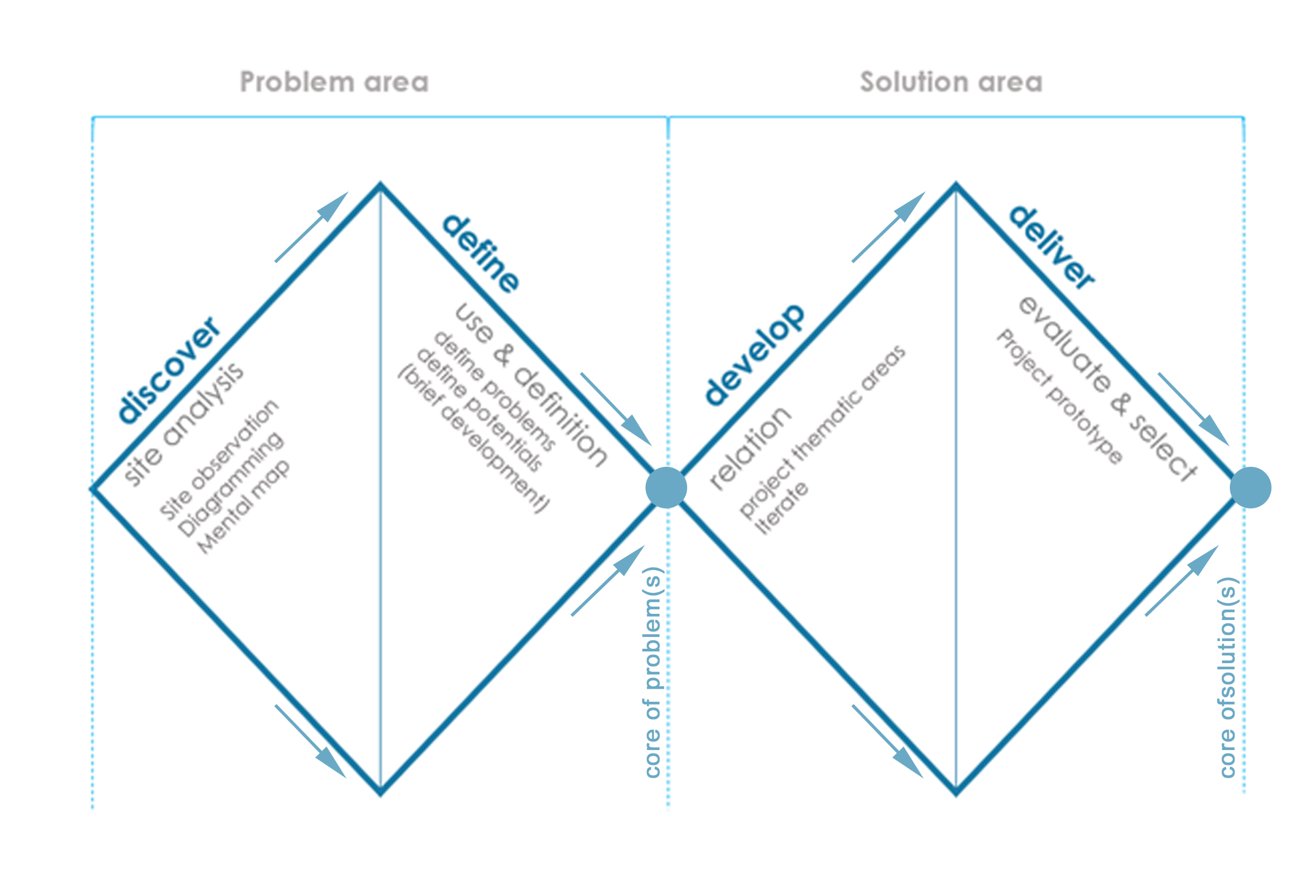
In detail, the first diamond, called problem area, encompasses both the site analysis and the problem individuation. Under the section discover, three main practical tools to understand the linear voids are identified: site observation; diagramming the site; and mental maps used as a form of engagement with users. Moving along the diagonals, the section define is further articulated with the definition of the potentials or, in other words, the strategic definitions (Royal Institution of British Architects, RIBA stage 0) that will feed into the brief development. Having completed the problem area, all the data are collected and interpretated in preparation for the next stage, which concerns the second diamond, called solution area. Develop is enhanced by the individuation of thematic areas and the iteration of design proposals, while the final deliver section includes the prototype as per the original DD framework. The sequence of convergent and divergent thinking contributes to the identification of the core of problem(s) and its solution(s).
In order to better understand the process followed during the case study analysis and development of urban and architectural design solutions, the next subparagraph outlines the context of the inclusive approach to site analysis for linear voids for transportation.
Inclusive approach to site analysis
The applicative study of linear voids is here intended as a qualitative ethnographic study that explores how the space may enhance or limit social interactions by adopting a set of on-site observations and recordings.
Interpretative diagrams of the former Deeside Railway, now converted into public path in Aberdeen, are drawn after site observations, in order to identify the main urban relations between the linear element and the surroundings. In the meantime, the human flows and emerging environmental patterns, which are currently not present in the current maps, are discovered and synthetised. The definition of patterns derives from the Gestalt theory7, which recognises our common perceptive process of categorising spaces based on similarity and hierarchy, and thus facilitates the understanding of environmental elements that play important roles in the definition of the local identity.
In addition to interpretative diagrams, the analysis attempts to assess the context for approaches of inclusive design by using graphic interviews of citizens who usually pass through the Deeside line in Aberdeen during their daily routines. The origins of graphic interviews are linked to Lynch8 and better known as mental maps, which graphically impose order and meaning on the objects present on the land. This research toolkit enables one to clarify the commonly perceived main elements of the site and to better draw a collective picture of the area. Emphasis on people’s perception is later used to classify instances of linear urban voids within macro-thematic areas and to delineate, in broad-brush terms, a number of central design tenets.
The outlined methodology is validated in subsequent paragraphs, in which work carried out by students during a one-year architecture design studio module at Scott Sutherland School of Architecture is presented and described.
Areas of investigation: Problem and solution
The first method adopted to better understand the spatial dynamics and actual use of the case study taken in examination, the former Deeside Railway in Aberdeen, consists of prolonged observations of the site recorded with photographs and diagrams. The latter are particularly helpful for a deeper comprehension of the rhythmicality of the area in terms of users’ flows and frequentation intensity in relation to the time of the day (i.e. morning and afternoon). Additionally, other emerging environmental patterns appear, such as the realistic use of the path, either in conjunction or disjunction with the surrounding spaces.
The collection of photographs and frequentation patterns is thus translated into consistent diagrams that enable one to overcome the static perception of the place on map by consequently supporting the dynamic definition of the problem area. In detail, as shown in the exemplar of the rhythm diagram below (see figure 3), the users’ flow is clearly limited by the geometry of the space and by poor accessibility while, in terms of time, the former railway displays patterns of more affluence and frequentation during the afternoon time.
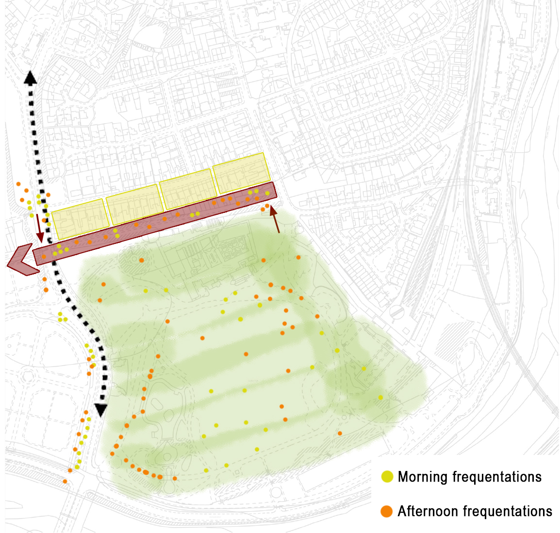
This brief description of the analysis undertaken highlights the real nature of this linear void, which is still used as transient space rather than a final destination. In other words, the common tendency is only to pass through the Deeside Way and to not go there to appreciate, stay or use the space except as a path.
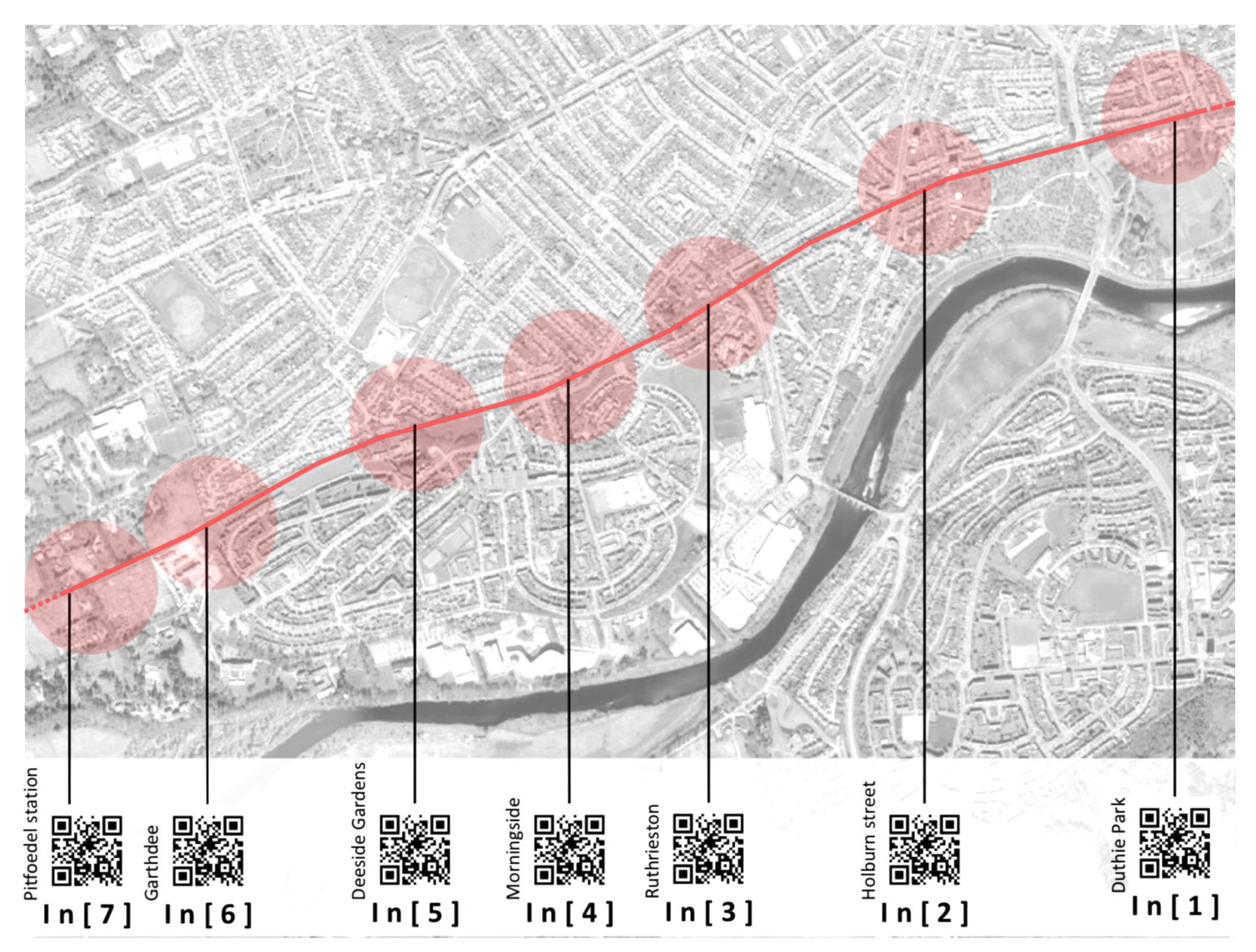
These initial considerations are then corroborated through inclusive principles of engaging with users by in-depth interviews and mental maps collection. Findings support the theory that users do not spend time on the Deeside Way; rather, they often use it as a short-cut to go to other areas in the city or the park (see figure 4).
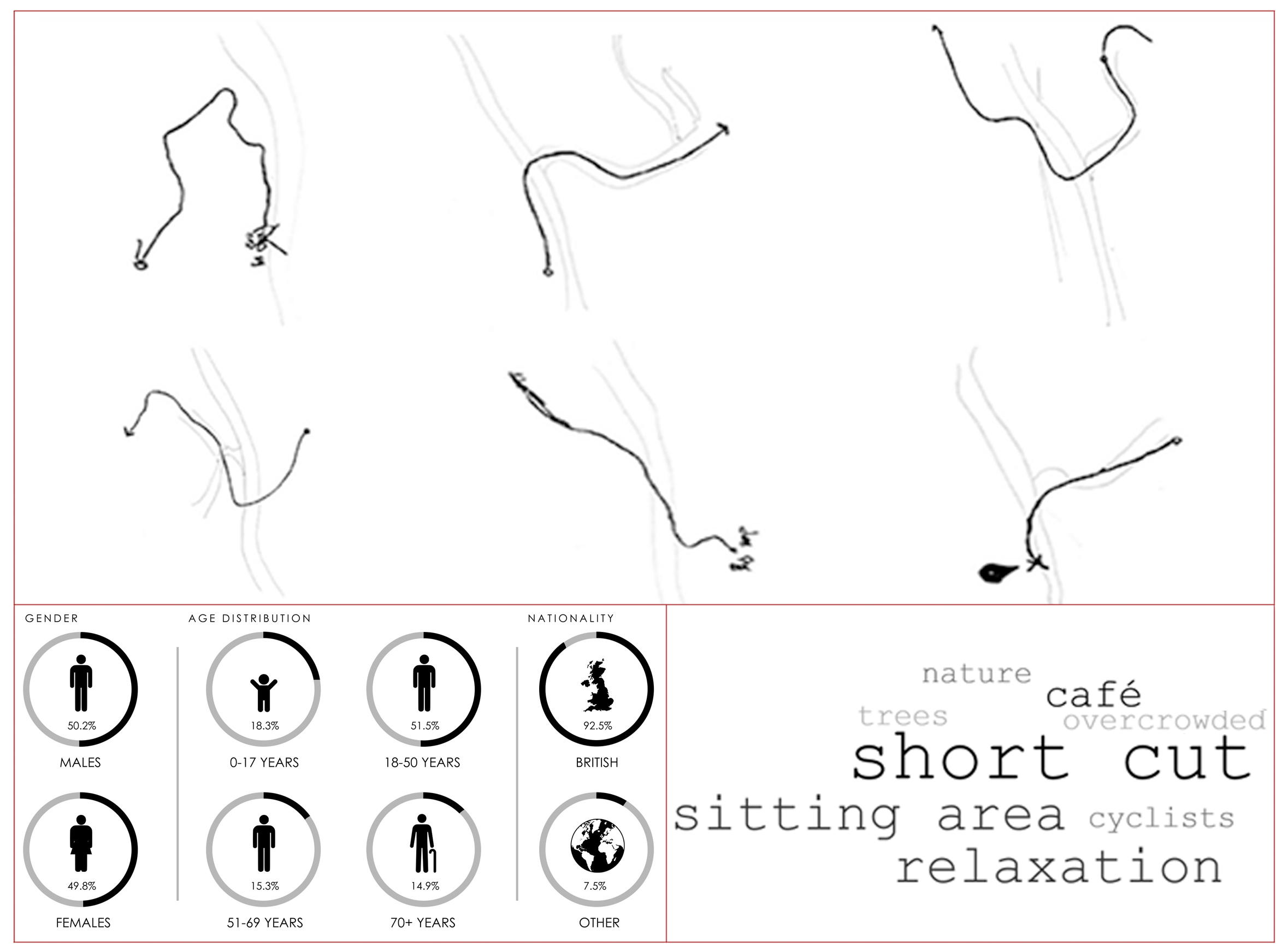
The thematic analysis of several interviews, carried out by students during the problem area investigation, highlights the paradoxical nature of the Deeside Way of being an element of connection and isolation at the same time. The limiting number of access points and its narrow width contribute to the denial of any relations with the surrounding areas.
A common consensus is that more attractions and resting areas are needed to break down the linear nature of the path and give more purpose to the Deeside Way. Furthermore, the surrounding areas could potentially become dense areas of social value through a coherent architectural and urban design, which, by taking advantage of the inclusive methods of analysis, may contribute to a sense of permanence, diversity and more spontaneous use of the path overall.
Solution area of investigations
According to Elisa Iturbe9, the presence of “lines” in our cities – as long they do not become barriers – is not necessarily negative, rather the opposite. We suggest to shift the attention from the notion of a line dividing two spaces to one of a porous boundary that embraces multiple functions and seeks to re-establish relations between adjoining areas. In a period of economic recession, developments based solely on demolitions and reconstructions, or speculative conversion of voids, are not always viable solutions. The respective boundaries of the linear urban voids appear to offer potential for interventions of adaptive re-use, which are both creative and sensitive to the local contexts. We argue that when boundaries achieve density10, they might become places of contaminations between the existing surroundings.
“Architecture is a field of thinking rather than doing, a field of reflection. The most important thing of architecture is to find the potentials. That means to do more than a building and to do more than a programme. Finding potentials means finding possibilities for the community and for the urbanity.”11
- Herzog, J. 2016
The structured analysis process and in-depth interview with citizens enabled the real potential of the site to be envisaged in relation to design and governance. The students proposed several design principles and most of them were developed according to ESG. The environmental (E) aspects were met by improving the quality of the spaces through a de-linearisation of the Deeside Way while enhancing the sense of local identity and history of the places; regarding the social aspects (S), the diversification of functions and the recognition of the space as void, which does not need to be filled with new building, enabled the creation of more inclusive and spontaneous spaces; and, finally, the governance (G) was intended as a bottom-up process to overcome the only mainstream economy offers by proposing new forms and models of management and ownership12.
Each group of students worked on different strategic points along the line (see figure 5) and designed landmark elements, which visually invite people to stay, take part in activities offered by the architectural project, and engage more with the surrounding spaces.
The process of iterating the design principles led to an accurate evaluation of the prototypes, which could be further developed. In this sense, several main concepts emerged as best design practices. While there is no space here to describe and provide further conceptualisations of all design principles, it’s nonetheless possible to explain briefly the main three design concepts corroborated by the process of iteration: space de-linearisation, street-level stitching and porous boundaries, all intervening along the path.
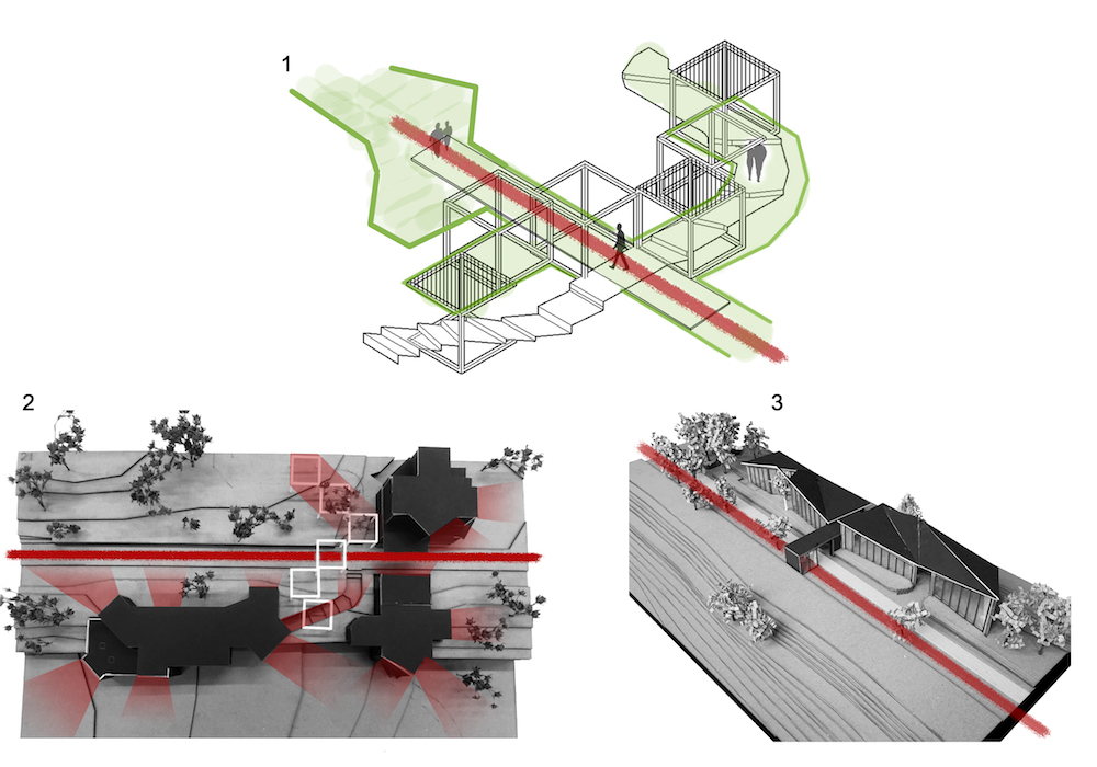
All three principles are meant as actions of expanding and reinforcing the Deeside Way, challenging its linearity. In detail, the projects challenge the relations between the line and the surrounding spaces, opening up their social potential, albeit maintaining the original identity of a former infrastructure for transportation.
Conclusions and recommendations
The escalating presence of urban voids in our cities as a result of the Covid-19 pandemic is evident. It poses, perhaps, one of the most profound challenges that the social, political and economic establishment has ever had to confront. We believe that this complex urban phenomenon needs to be urgently addressed. However, the first milestone in this process consists in a public recognition of the importance of the voids as fundamental components of our cities. As Geert Bekaert has said, “the empty space is no longer characterised as negative from the very start but as equal to the built space. It no longer serves as background for figures in the foreground.”13 Placing built space and empty space on the same level of significance – ‘figure’ and ‘background’, in Bekaert’s words – doesn’t mean that architecture is obliged to design everything, but it does give any architectural project the right to design anything, including its absence.
By drawing on the results of the research through design on linear urban void for transportation in Aberdeen, this paper suggests that every urban void must be freed from a negative connotation of dysfunctional space. Instead, it must be considered as never neutral and empty, but rather as always “tensioned”, both made and occupied by forces that produce and use them. By focusing on the relational aspects pushes us to rethink the reality of linear urban voids in terms of relations, instead of objects, entities or substances, where all properties are relational. The process of mapping the network of relationships, of which the architectural is only one of the possible codified forms of expression, becomes the key for any form of intervention. Anything that exists does so thanks to, as a function of, or according to the perspective of something else.
In continuity with the adopted methodology of revised DD, the core of problem(s) is consistently developed in the solution(s) area. The intrinsic relational structure of the urban voids continues all the way down to the practical/physical level of designing forms of intervention. This study has demonstrated that the voids are dense spaces full of other alternative potential, which are not necessarily mainstream economic or in alignment with strategies of permanent appropriation and codification of public space. Their peculiarities encourage business with robust ESG frameworks.
If we’re able to visualise the voids under a different perspective, we can assert that they embody active forms of social relations. They give form to encounters because they are a structured system of relations where people can handle and symbolise various levels and forms of proximity.
By becoming potential urban spaces, the field of intervention expands its domain in a dynamic sense into a set of design principles and eventually overcomes the non-coincidence between architecture and the city, between the built and the un-built, between urban environment design and human-centred design approach.
About the authors
Silvia Bassanese, MSc Architecture, MSc Visual Art, is an architect and a lecturer in design at the Scott Sutherland School of Architecture and Built Environment. Dr Cecilia Zecca, PhD, PgCert, Msc, March, FHEA is an architect and a postdoctoral research associate at the Helen Hamlyn Centre for Design, Royal College of Art.
Acknowledgements
The Deeside Way was investigated during the design process work of various design studios at the Scott Sutherland School of Architecture and Built Environment, Robert Gordon University, in Aberdeen, between 2018 and 2019. We are grateful to the students who have supported the research through their work.
References
- Aureli, PV, (ed.). (2013). The City as a Project. Berlin: Ruby Press.
- Lopez-Pineiro, S. (2020). A Glossary of Urban Voids. Berlin: Jovis.
- Holland, J. (2015). Exploring Britain’s Lost Railways; 278-283. Glasgow: Collins.
- Zecca, C and Laing, R. (2022). Border[s]lines between isolation and connection: The disused railway in Aberdeen. In Zaman, QM and Hall, GG. (2022). Bored Urbanism. Series ISSN: 2365-757X. Springer Cham.
- Bassanese, S and Zecca, C. (2020). Between isolation and re-appropriation: Potential of linear urban voids. The City and Complexity. Life, Design and Commerce in the Built Environment. Conference proceeding, Amps, City University of London.
- British Design Council. (2004). Available at: Framework for Innovation: Design Council’s evolved Double Diamond – Design Council. https://www.designcouncil.org.uk/our-work/skills-learning/tools-frameworks/framework-for-innovation-design-councils-evolved-double-diamond/
- Sema Uzunoglu, S and Uzunoglu, K. (2011). The Application of Formal Perception of Gestalt in Architectural Education. Amsterdam: Elsevier.
- Lynch, K. (1960). The Image of the City. Cambridge: MIT Press.
- Iturbe, E. (2017). The Border is Not a Line. Log 39; 111-117.
- Stoppani, T. (2014). Relational architecture: Dense voids and violent laughters. Field: 6; 97-111. Accessed 6 August, 2022. http://field-journal.org/portfolio-items/field-6-urbanblind-spots/
- Herzog, J. (2016). Hardly Finished Work. Cambridge: Harvard GSD.
- Colander, D and Kupers, R. (2014). Nudging toward a complexity policy frame. In Complexity and the Art of Public Policy: Solving Society’s Problems from the Bottom Up; 156-176. Oxford: Princeton University Press.
- Bekaert, G. The hereafter of the city. (2002). In After-Sprawl: Research on the Contemporary City, edited by Xaveer De Geyter Architects; 35. Rotterdam: NAi Publishers.
Further reading
- Abrahamsson, S and Simpson, P. (2011). The limits of the body: Boundaries, capacities, thresholds. Social and Cultural Geography. 12; 331-338.
- Emerson, T. (Studio). (2017). Glasgow Atlas, ETH Zürich.
- Stavrides, S. (2014). Open space appropriations and the potentialities of a city of thresholds. In Terrain Vague: Interstices at the Edge of Pale, edited by Mariani, M and Barron, P. New York: Routledge.
- Stavrides, S. (2013). Contested urban rhythms: From the industrial city to the post-industrial urban archipelago. In Urban Rhythms: Mobilities, Space and Interaction in the Contemporary City, edited by Smith, R and Hetherington, K. London: Wiley-Blackwell.